
Lush green forest adorned with pine and rhododendron trees, vibrant villages, lovely people, and the majestic Himalayas add to the region’s beauty, making the Annapurna region into what it is- a home for adventurers all around the world.
Annapurna Base Camp Trek allows being face to face with the world’s tenth highest peak, Mt. Annapurna (8,091m), along with Machhapuchhre (6,993m), Hiunchuli (6,441m), and Dhaulagiri (8,167m).
The Annapurna Base Camp (ABC) Trek passes through the Annapurna Conservation Area, known for its natural wonders that are not found anywhere else on the planet.
In comparison to some of the other high-altitude treks in Nepal, the Annapurna Base Camp Trek is easily accessible, affordable, and the most thrilling.
The trek is fun for beginners and experienced alike.
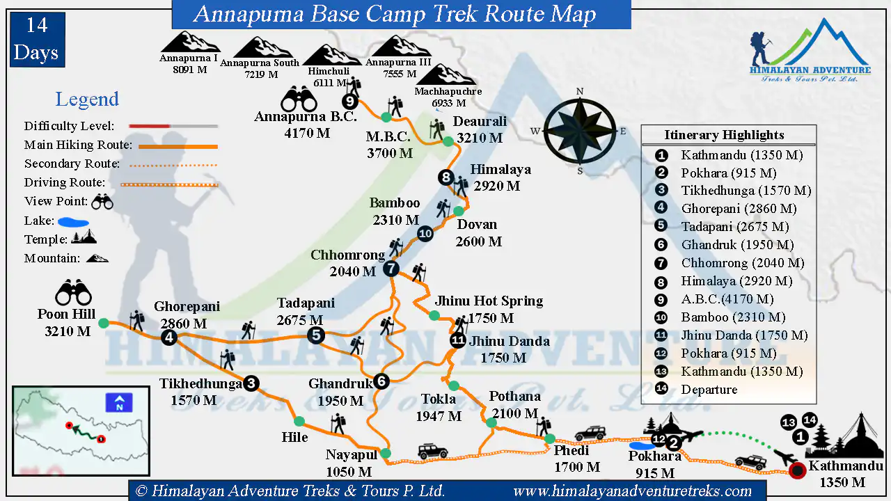
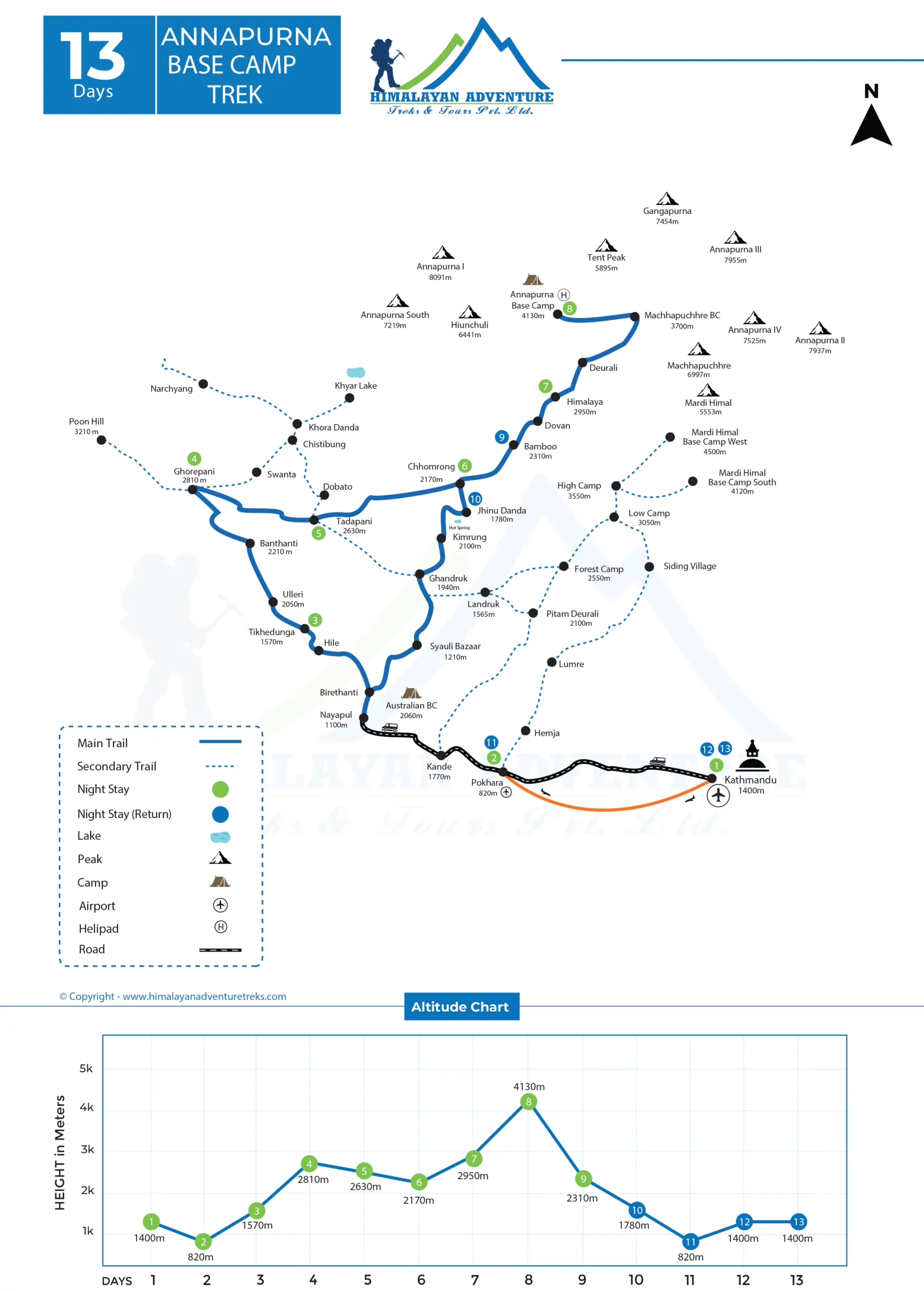
Trekking takes 13 days, from Kathmandu to Annapurna Base Camp and Kathmandu.
The Annapurna Base Camp is located at the foot of the majestic Mount Annapurna (8,091m). The base camp is 4,130 meters, the highest altitude in the entire trek.
Annapurna Base Camp Trek is the perfect choice if you are up for discovering the diverse landscape, rich cultural lives, and quenching the thirst for mountain views
Although this is a moderate grade trek and you are always with the community, the trekking trail includes several possibilities, leading to destinations that are not the planned destinations.
So, make sure that the Annapurna Base Camp Trek Map is always with you.
Though handheld GPS may be more convenient, you can download and mark the paths you want to take. However, you should not rely entirely on them. This is because you can drop them, or you may not receive sufficient satellite coverage for them to be helpful.
Also, the Annapurna Base Camp Trek Route Map helps you plan your routes and find the right place to stay. A map is not just a picture of a place but a connection to memories of that place.
Summary
The trip officially begins once you set foot at the Tribhuvan International airport of Nepal.
You will check into a hotel and rest for the rest of the day. In the evening, you can visit the many eateries and sites of the capital or do some last-minute shopping.
Rise and shine, for the adventure awaits today!
Today, travel to the beautiful city of Pokhara. This can be done by flight (a 30-minute flight) or by bus for 6-7 hours. You will see terrace farms, scenic valleys, and roadside settlements while ringing in the local Nepali music if you choose the latter.
When you arrive at Pokhara, first check into your hotel room.
In the evening, you can boat in Phewa Lake, visit the many shops, try some local food, or take in the fascinating nightlife of Lakeside. But don’t stay up late too much as the trek begins to unfold.
On the third day, you will travel by road to Nayapul (1,050 meters). Then you finally start your trek as you walk to Tikhedhunga (1,570 meters), traveling along rivers and passing many scenic villages.
The next day, you cross many villages as you ascend stone stairs until you finally reach the village of Ghorepani (2,860 meters).
On the fifth day, you will trek to Poon Hill (3,210 meters) before sunrise to take in the glorious rays as the sun rises over the Annapurna and Dhaulagiri massifs.
Then return to Ghorepani and then to Tadapani (2,675 meters), where you will spend the night.
On the sixth day, you will travel to the famous village of Ghandruk (1,950 meters).
On the seventh day, you travel to the village of Chhomrong (2,040 meters), walking through valleys and crossing rivers.
On the eighth day, you head towards the Himalaya (2,920 meters), passing by the villages of Sinuwa (2,220 meters), Bamboo (2,310 meters), and Dobhan (2,600 meters).
On the ninth day, you finally reach Annapurna Base Camp (4170 meters) by trekking past Macchapuchhre Base Camp (3,700 meters). The Annapurna Base Camp Trek Route Map will surely come in handy today. You will spend the night in the Base Camp itself.
On the tenth day, you descend back to Bamboo.
The next day, you again descend to Jhinu Danda (1,750 meters) and visit the famous natural hot springs.
The twelfth day is the last day of the trek, where you will be descending back to Nayapul, passing through Landruk (1,565 meters) and Tolkha (1,710 meters) villages. From there, you travel by road to Pokhara.
On the thirteenth day, drive back to Kathmandu. The next day, the trip ends as you board a flight back home.
Key Highlights of the Annapurna Base Camp Trek
- Get great and up-close views of many peaks of the Annapurna and Dhaulagiri ranges, which include Annapurna I (8,091 meters), South (7,219 meters), II (7,937 meters), III (7,555 meters), Hiunchuli (6441 meters), Nilgiri (7,061 meters), Macchapuchhre (6,993 meters), Gangapurna (7,455 meters).
- Covers two base camps, Annapurna and Machhapuchhre, at the cost of one.
- Over 14 species of rhododendron flowers turn the entire forest into a painting with their contrasting colors.
- Boat in the mesmerizing Phewa Lake and enjoy the reflection of the Himalayan giants in the lake.
- Experience the lifestyle of the Gurung and Magar people, known throughout the world as ‘Gurkhas,’ fierce warriors of Nepal.
- Witness the biodiversity of Annapurna Conservation Area and many rare and endangered species such as the red panda, snow leopard, musk deer, etc.
- Watch the first rays of dawn turn the white snow of the Annapurna and Dhaulagiri ranges to molten gold from Poon Hill.
Annapurna Base Camp Trek Route Details
Arrival in Kathmandu (1450m)
Touching down at Tribhuvan International, you will be welcomed by our office representatives, who will guide you directly to the hotel.
Freshening up from the day’s adventure, you will be introduced to other staff members, including your guides for the trip, who will brief you on the day-to-day itinerary.
With the activities for the day coming to a close, you are free to head down to the local places to enjoy a pleasant evening. You can also do some last-minute shopping for any supplies you may need.
You are advised to pack the Annapurna Base Camp Trek Route Map for safety reasons.
Drive from Kathmandu to Pokhara (915m), 6-7 hours
We begin our journey with a scenic adventure heading to the picturesque city of Pokhara.
We leave the capital early and follow the winding bends of the Prithivi Highway to vibrant settlements and stunning towns.
Accompanied by the raging Trishuli River mid-way, the hilly path leads us west to Pokhara. The city is blessed with breathtaking natural beauty and is frequently visited by trekkers entering and exiting the Annapurna region.
You can take a night walk along the shores of Phewa Lake or take a boat trip on the beautiful Phewa Lake. You can also visit many restaurants and clubs in the city.
Drive from Pokhara to Nayapul (1050m) and trek to Tikhedhunga (1570m), 3-4 hours
The trek officially begins today.
At first, you will drive to Nayapul (1050 meters), a travel distance of 45 km, taking about 2 hours. Upon reaching Nayapul, your journey on foot begins.
You cross a suspension bridge over the mighty Modi Khola and follow a gentle path through the bamboo forest until you reach (1039 meters). The settlement is at the confluence of the Burundi and Modi rivers.
The trail from Birethanti consists of well-maintained stone steps. These steps are not so steep and therefore provide a comfortable hiking experience.
After covering a distance of about 9 km, you will finally reach your destination, Tikhedhunga (1570 meters). On this day, you exceeded an altitude of 520 meters.
Trek from Tikhedhunga to Ghorepani (2860m), 6-7 hours
On the fourth day of your trip, we will ascend to Ghorepani (2,860 meters).
As you keep moving up the stone steps, you pass through the village of Ulleri (1,920 meters). The beautiful Annapurna and the Dhaulagiri views will captivate you during the trek.
The trail from here is gently uphill, and you will travel through pathways shrouded with greenery. The oak tree and rhododendron forest provide cool shade for a walk.
Ascending further, you pass through the villages of Banthanti (2,250 meters) and Nangethanti (2,460 meters) until, eventually, you reach Ghorepani (2,860 meters).
Ghorepani is famous for its rhododendrons. You can see the entire forest full of red rhododendron flowers, given the right season.
On this day, you hiked about 13 km and climbed 1290 meters.
Trek from Ghorepani to Tadapani (2675 meters) via Poon Hill (3210 meters), 6-7 hours
Today, you will get to see the first rays of sunshine hit the pristine snow of the Annapurna and Dhaulagiri mountains, so a unique experience awaits you. You leave before dawn and head to Poon Hill (3,210 meters).
This famous viewpoint has earned its fame due to the almost dream-like panorama it provides. You need to climb a steep uphill trail to get here.
Once here, you can see the sun’s early rays turn the Annapurna and Dhaulagiri ranges into mountains of molten gold.
Some of the peaks you can see from here include Annapurna I, II, III, South, Nilgiri, Hiunchuli, etc.
To reach Poon Hill from Ghorepani, you need to cover a distance of about 1.5 km and a vertical descent of 350 m.
Once you are satisfied with these fantastic views, you return to Ghorepani. Then, descend into the dense and mossy rhododendron forests. These forests are home to more than 14 species of rhododendron.
After walking for hours, you finally arrive at Tadapani (2,675 meters). To do this, you will have to travel a distance of about 10 km and descend an altitude of 185 meters.
Trek from Tadapani to Chhomrong (2040 meters), 5-6 hours
Today, you leave Tadapani and head towards Chhomrong (2,040 meters). At first, the trail is a slight uphill. After reaching the top of the hill, you descend steeply to the Kimrong Khola.
The trail passes through lush oak and rhododendron forests, and you can hear soft calls from birds and other animals as you walk.
Once there, you cross the suspension bridge over it and then start an uphill climb. Although the trail has a steep ascent and descent, the terrain is smooth, so you will not have much difficulty traveling.
This part of the trip is also more isolated, so you will be free to travel in peace. Walking for some more time, you will finally reach Chhomrong.
On this day, you covered about 10 km and climbed 90 meters.
Trek from Chhomrong to Himalaya (2920 meters), 5-6 hours
The sixth day of this trip starts by descending the Chhomrong Khola along a stone-paved path. You will cross the river through a suspension bridge and immediately start climbing.
As on the day before, the trail is surrounded by greenery.
Most of the trails are made up of stone steps. If you don’t know the route, refer to the Annapurna Base Camp Trek Route Map.
After walking for about 2-3 hours, you will reach the village of Sinuwa (2,220 meters). From here, the trail goes up a little and then descends to the village of Bamboo (2,310 meters).
Then, as you travel uphill, crossing the settlement of Dobhan (2,600 meters), you finally reach the Himalaya (2920 meters), located at the foot of the Hiunchuli peak.
On this day, you covered 10 km and ascended 880 meters.
Trek from the Himalaya to Annapurna Base Camp (ABC) (4170 meters), 6-7 hours
Today, you reach your ultimate destination, as at least you set foot in the Annapurna Base Camp (4170 meters).
Trekking begins early in the morning and descends to the village of Deurali. From Deurali, you travel uphill until you reach Macchapuchhre Base Camp (3,700 meters).
From here, you travel along the moraines of the Annapurna South. As most of the trail is a gradual incline towards the camp, you will not have much problem with altitude sickness.
After walking uphill for a while, you finally reach the base camp. From here, you can see the fascinating view of the Annapurna Massif along with Machhapuchhre (6,993 meters), Gandharva Chuli (6248 meters), Gangapurna (7,455 meters), and others.
Take plenty of shots to remember this victorious day. Tonight should be as memorable as spending time at the foot of the 10th-highest mountain in the world.
On this day, you covered 9.1 km and climbed 1,250 meters.
Trek from Annapurna Base Camp to Bamboo (2310 meters), 5-6 hours
When you wake up at Annapurna Base Camp, you can see the morning sun illuminating the Annapurna Mountains.
You say goodbye to the base camp and descend towards the Bamboo (2,310 meters).
The trail will follow the rough path along the moraine of the Annapurna. Since this is the Himalaya, the trail is by no means an easy descent, and there are also some climbs. Therefore, follow the Annapurna Base Camp Trek Route Map to track your route.
You first descend towards the Machhapuchhre Base Camp, then to Deurali, Himalaya, and Dobhan.
Finally, you reach Bamboo after walking 12.7 km and descending an altitude of 1,860 meters.
Trek from Bamboo to Jhinu Danda (Hot Spring) (1750 meters), 5-6 hours
Early in the morning, you head to Jhinu Danda (1750 meters) to take a bath in the hot springs.
However, to get there, you will have to walk about 11.7 km and descend 560 meters.
You start the trek by descending along trails, with most sections being stone staircases.
Descending past Sinuwa, you can see Chhomrong, the next settlement, right in front of you. However, to reach it, you need to descend to the Chhomrong Khola, cross the suspension bridge, and then ascend to the village.
From Chhomrong, you again descend until you reach Jhinu Danda.
Here, you check in at the lodge where you spend the night and then make your way to the natural hot springs about 50 meters down for a dip, leaving the heavier gear behind.
After a continuous walk for almost a week, relax and soothe your tired muscles with the bubbling water of the hot springs.
Today you cover a distance of 8.5 km and descend an altitude of 560 meters.
Trek from Jhinu Danda to Pokhara via Nayapul, 4-5 hours
Today is the day you sadly leave behind the Annapurna range for your next adventure.
Descending mostly stone-paved staircases, you pass Landruk (1,565 meters) and Tolkha (1,710 meters) before finally reaching Nayapul.
Once you reach it, you will have traveled 4.3 km on foot and descended 700 m.
From Nayapul, you will catch a tourist bus to Pokhara. As you have to travel a distance of 45 km, it will probably take you about 2 hours.
Drive from Pokhara to Kathmandu, 6-7 hours
Today, you bid farewell to the Annapurna region as you drive from Pokhara to Kathmandu.
Traveling along the smooth paved roads, watching the countryside unfold outside your window, the myriad of rivers you travel along, and remembering your hopefully enjoyable trek.
Final Departure
The Return Journey is filled with memories of the last 13 days.
Until you come back again, it will serve as a warm memory. Arrival at the airport is required at least 3 hours before departure.
Annapurna Base Camp Trek Permits
The Annapurna region falls under the Annapurna Conservation Area Project (ACAP) and requires an ACAP entry permit. In addition, Annapurna Base Camp Trekking requires a Trekker’s Information Management System (TIMS) card.
Both are mandatory and can be easily obtained with a copy of your passport and passport-sized photographs. You also need to have travel insurance.
The TIMS card and ACAP permit are available from the Nepal Tourism Board (NTB), Bhrikutimandap, which is open from 10 am to 5 pm, seven days a week. TIMS Cards can also be obtained from the TIMS Counter at the NTB Regional Office in Pokhara.
The charges for the TIMS Card are as follows: Group trekker: NRs. 1,000 (equivalent to 10 USD); Free individual trekker (FIT): NRs. 2,000 (equivalent to 20 USD) per trekking route per person per entry. ACAP permit costs NRs. 3,000 (equivalent to 30 USD) per person per entry.
Best Season for Annapurna Base Camp Trek
The best seasons for trekking in this region are spring (March to May) and autumn (September to November).
During the spring, skies generally remain clear, and the views of the mountain peaks can be seen in stark contrast to the open valleys.
It is also one of the fascinating trekking months in Nepal as it experiences a huge surge of trekkers coming into the country to enjoy the trek with all of the good-weather perks.
There are meager chances of precipitation. The landscape remains vibrant and fresh.
Likewise, autumn offers moderate temperatures found in temperate landscapes. With warm sunny days and cool nights, autumn is an excellent time for trekking.
However, the Annapurna Base Camp trek could be done throughout the year.
Final words,
Surrounded by the majestic Annapurna Himalayan Range, the lush green valley of Annapurna has always been the go-to place for trekkers and adventurers alike, regardless of the kind of adventure they are seeking.
Himalayan Adventure Treks & Tours made the Annapurna Base Camp Trek Route Map possible with on-site research and information.
This map will be your travel companion, so keep it safe throughout your journey.
