
Manaslu Circuit Trek: A Gateway to Serenity and Adventure
The Manaslu Circuit Trek 14 days is a breathtaking adventure that circumnavigates Mount Manaslu (8,163 meters), the world’s eighth-highest peak, located in the Gorkha District of Nepal. It is a captivating journey offering a blend of cultural exploration, serene landscapes, and thrilling trekking experiences. Renowned for its remote trails, pristine environments, and unparalleled views of the Himalayan range, the trek traverses the Manaslu Conservation Area, which is rich in biodiversity and cultural heritage.
The trail starts in the subtropical lowlands and ascends to the alpine region, culminating in the challenging yet rewarding Larkya La Pass at 5,160 meters (16,929 ft). The trek is ideal for adventurers seeking solitude and cultural immersion while avoiding the crowds of more commercialized treks like the Everest Base Camp Trek or the Annapurna Circuit Trek.
Manaslu Circuit Trek Map: A Comprehensive Guide
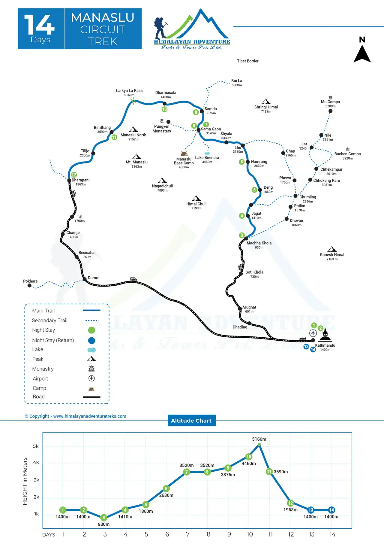
The Manaslu Circuit Trek Map serves as a crucial tool for navigating one of Nepal’s most iconic and remote trekking routes. This map offers a visual representation of the trek’s trails, key landmarks, altitudes, distances, and geographical features, providing trekkers with essential information to plan their journey. Below is a detailed explanation of the map and its significance.
Key Features of the Manaslu Circuit Trek Map
- Starting and Ending Points
- Start: The trek begins at Machha Khola (869m), a small village along the Budhi Gandaki River, reached after a long drive from Kathmandu.
- End: The trek concludes at Dharapani (1,963m), where you connect to the Annapurna Circuit trail before driving back to Kathmandu.
Significance: These locations mark the entry and exit points of the Manaslu Conservation Area, ensuring trekkers adhere to permit guidelines.
- Trail Path
- The trail follows the Budhi Gandaki River for most of the journey, weaving through forests, gorges, and villages like Jagat, Deng, Namrung, and Sama Gaon.
- The path eventually ascends to the high-altitude Larkya La Pass (5,160m) before descending to Bimthang and Dharapani.
Significance: The map highlights steep ascents, descents, and relatively flat stretches, helping trekkers gauge the difficulty of each section.
- Altitude Profile
- Starting at ~869m, the trek reaches its highest point at Larkya La Pass (5,160m) before descending.
- The map provides an altitude chart to visualize elevation changes, which is vital for planning acclimatization days.
Significance: This feature is critical for understanding how altitude impacts trekking and minimizing the risk of altitude sickness.
- Key Villages and Stops
The map marks significant stops such as:- Jagat: Gateway to the Manaslu Conservation Area.
- Namrung: A cultural hotspot showcasing Tibetan heritage.
- Sama Gaon: A key acclimatization spot with access to Manaslu Base Camp.
- Samdo: A high-altitude Tibetan village near the border with China.
- Dharamsala (Larkya Phedi): The base camp for Larkya La Pass.
Significance: These stops help trekkers divide their journey into manageable sections and identify locations for food, lodging, and cultural experiences.
- Natural Landmarks
- Rivers: The map outlines the path of the Budhi Gandaki, Dudh Khola, and Marsyangdi Rivers, essential for hydration and orientation.
- Glaciers and Lakes: Includes landmarks like Birendra Lake and glaciers near Manaslu Base Camp.
Significance: Knowing these landmarks helps trekkers stay on track and enjoy the natural beauty along the way.
- Conservation Areas
- The trek passes through the Manaslu Conservation Area and partially overlaps with the Annapurna Conservation Area towards the end.
- The map also highlights protected zones rich in biodiversity, such as rhododendron forests and alpine meadows.
Significance: These areas are essential for trekkers to understand the need for permits and sustainable trekking practices.
- Larkya La Pass
- The map prominently marks the Larkya La Pass, showing its approach and descent routes.
- Includes details about high-altitude hazards and rest stops like Dharamsala.
Significance: As the trek’s most challenging section, this feature ensures trekkers are prepared for the rugged terrain and extreme weather conditions.
- Distances and Times
- Each section of the trek is labeled with approximate distances in kilometers and trekking hours.
- For example, the map shows that the distance from Machha Khola to Jagat is about 22 km, taking 7–8 hours.
Significance: This information aids in pacing and planning daily itineraries.
- Trekking Routes and Alternatives
- Highlights the main trail and possible detours, such as hikes to Manaslu Base Camp or exploration of side villages.
- Some maps include connections to other treks like the Annapurna Circuit.
Significance: Helps trekkers customize their journey according to time, interest, and fitness level.
Importance of the Manaslu Circuit Trek Map for Trekkers
- Navigation and Orientation: The Manaslu Circuit Trek map provides detailed topographical information, ensuring trekkers stay on course, especially in remote areas with fewer signposts.
- Planning and Preparation: Knowing the altitude profile, distances, and time estimates allows trekkers to plan for acclimatization, food supplies, and rest days.
- Safety and Emergency: The map includes emergency shelters, medical facilities, and exit routes, which are vital for dealing with unforeseen circumstances like injuries or extreme weather.
- Cultural and Natural Exploration: Highlights monasteries, villages, and biodiversity hotspots, enriching the trekking experience by pointing out key sites of interest.
Tips for Using the Manaslu Circuit Trek Map
- Get a Reliable Map: Opt for maps from trusted publishers like Nepal Trekking Maps or GPS-enabled apps like Maps.me. Ensure the map includes updated information on trails and landmarks.
- Combine with a Guide: While maps are helpful, a professional guide can provide real-time advice, local knowledge, and updates on weather and trail conditions.
- Understand Symbols and Legends: Familiarize yourself with the map’s symbols for trails, rivers, and landmarks to avoid confusion during the trek.
- Use Offline Tools: Carry a physical map or download offline versions, as internet connectivity is limited in the region.
Final Thoughts
The Manaslu Circuit Trek Map is more than a navigational aid; it’s a gateway to understanding the region’s geography, culture, and biodiversity. Whether you’re a first-time trekker or a seasoned adventurer, using this map effectively ensures a safer, more enjoyable, and enriching experience on the trail.
Manaslu Circuit Trek -14 Day Detailed Itinerary
Day 01: Arrival at Kathmandu Airport (1,334m / 4,376 ft)
Your adventure begins upon arrival at Tribhuvan International Airport, Kathmandu. You’ll be greeted by spectacular views of the Himalayas during your descent into the valley. After checking into your hotel in Thamel, you can explore local markets, temples, and restaurants. This day is for rest and preparation, where permits such as the Manaslu Restricted Area Permit and Manaslu Conservation Area Permit (MCAP) are finalized.
Day 02: Kathmandu Valley Sightseeing and Trek Preparation
Explore UNESCO World Heritage Sites such as Pashupatinath Temple, Boudhanath Stupa, and Kathmandu Durbar Square. These landmarks offer a glimpse into Nepal’s rich cultural history. In the afternoon, meet your trekking guide and finalize gear for the journey.
Day 03: Drive from Kathmandu to Machha Khola (869m / 2,851 ft)
Distance: ~140 km | Duration: 8–9 hours
The drive winds through lush hills, terraced farms, and riversides. Passing through Dhading and Arughat, you’ll reach the small village of Machha Khola. The drive is a blend of excitement and stunning scenery, with the Budhi Gandaki River accompanying most of the way.
Day 04: Trek from Machha Khola to Jagat (1,340m / 4,396 ft)
Distance: ~22 km | Duration: 7–8 hours
The trek follows narrow trails alongside the Budhi Gandaki River, crossing suspension bridges and passing small settlements. Highlights include the Tatopani hot springs, ideal for relaxation, and the transition to the Manaslu Conservation Area at Jagat, known for its stone-paved streets.
Day 05: Trek from Jagat to Deng (1,860m / 6,102 ft)
Distance: ~19 km | Duration: 6–7 hours
The trail alternates between dense forests and open terrain, offering glimpses of Himalayan peaks. You’ll encounter cultural symbols such as mani walls and chortens, signifying the region’s Buddhist influence.
Day 06: Trek from Deng to Namrung (2,630m / 8,628 ft)
Distance: ~20 km | Duration: 6–7 hours
Pass through villages like Ghap and Bihi, surrounded by pine and rhododendron forests. As the altitude rises, enjoy breathtaking views of Ganesh Himal and nearby peaks. Namrung offers cultural and natural immersion, with locals showcasing traditional Tibetan lifestyles.
Day 07: Trek from Namrung to Sama Gaon (3,520m / 11,548 ft)
Distance: ~18 km | Duration: 4–5 hours
This section is rich in Tibetan cultural heritage, with monasteries and prayer flags adorning the trail. Sama Gaon offers incredible views of Mount Manaslu and opportunities to explore Ribung Gompa.
Day 08: Acclimatization Day at Sama Gaon
Spend the day hiking to Birendra Lake or Manaslu Base Camp (4,800m) to acclimatize. This is essential for adjusting to high altitudes. Enjoy close-up views of glaciers and peaks, making this day a visual feast.
Day 09: Trek from Sama Gaon to Samdo (3,875m / 12,713 ft)
Distance: ~16 km | Duration: 4–5 hours
The trek to Samdo is gradual, with mesmerizing views of Himalayan landscapes and the Tibetan border nearby. Samdo is a quaint village, home to yak herders and a vibrant Tibetan community.
Day 10: Trek from Samdo to Dharamsala (4,460m / 14,633 ft)
Distance: ~14 km | Duration: 4–5 hours
The trail ascends steadily to Dharamsala, the base camp for Larkya La Pass. The day is relatively short but offers stunning views of the surrounding peaks like Himlung Himal.
Day 11: Trek from Dharamsala to Bimthang (3,590m / 11,778 ft) via Larkya La Pass (5,160m / 16,929 ft)
Distance: ~24 km | Duration: 8–9 hours
Crossing the Larkya La Pass is the trek’s most challenging and rewarding segment. From the top, marvel at Annapurna II, Cheo Himal, and other peaks. Descend carefully to the peaceful village of Bimthang, surrounded by alpine meadows.
Day 12: Trek from Bimthang to Dharapani (1,963m / 6,440 ft)
Distance: ~20 km | Duration: 6–7 hours
The trail descends through forests and riversides, passing villages like Gho. The journey becomes less strenuous as you approach Dharapani, where the trek concludes.
Day 13: Drive from Dharapani to Kathmandu
Duration: 8–9 hours
The return journey by jeep offers a mix of excitement and nostalgia as you revisit the landscapes of the Manaslu region. Back in Kathmandu, you can enjoy a farewell dinner to celebrate your successful trek.
Day 14: Departure from Kathmandu
Your trekking adventure concludes with a transfer to Tribhuvan International Airport.
Conclusion:
The Manaslu Circuit Trek Map is an indispensable resource for anyone embarking on this adventurous journey through Nepal’s pristine wilderness. It offers a comprehensive view of the trail, highlighting key landmarks, altitudes, and trekking distances, which are vital for planning a successful trek. With detailed routes from Machha Khola to Dharapani, the map ensures trekkers are well informed about each day’s challenges and attractions. Its inclusion of geographical features such as the Budhi Gandaki River, Larkya La Pass, and Manaslu Base Camp enriches the trekking experience, helping adventurers connect with the region’s natural beauty.
The map’s altitude profile is particularly crucial for tackling high-altitude challenges, offering insights that aid in minimizing risks like altitude sickness. By marking key villages like Jagat, Namrung, Sama Gaon, and Samdo, the map also serves as a cultural guide, showcasing the Himalayan lifestyle and Tibetan influence in these remote settlements. Its focus on Manaslu Conservation Area and biodiversity highlights the need for sustainable trekking practices, aligning with the conservation efforts in the region.
For safety, the map pinpoints emergency shelters, rest stops, and alternative routes, ensuring trekkers are prepared for unforeseen circumstances. It also provides valuable data on trekking hours and distances, enabling efficient pacing and preparation. Whether you’re planning acclimatization at Sama Gaon or gearing up for the challenging ascent of Larkya La Pass, the map proves invaluable.
In essence, the Manaslu Circuit Trek Map not only guides trekkers through a physically demanding route but also enhances their connection to the region’s geography, culture, and ecosystems. With updated information and proper usage, it becomes a trekker’s best companion, making the adventure safer, more enjoyable, and a truly unforgettable journey with Himalayan Adventure Trekking.
