



The Budhi Gandaki River flood on 11 October 2026 has raised serious concerns about trekking access in Nepal’s Manaslu region. Initial reports indicate damage to bridges, riverside settlements, roads and sections of the lower trekking corridor in Gorkha District. As the fall trekking season begins, people who are already planning a trip should be aware of the potential impact of the damage on their trips.
It is not just the condition of the walking trails that is the immediate concern. The Manaslu Circuit relies on a series of bridges, village trails and road routes in the Budhi Gandaki Valley. If one of the crossings is damaged and trekkers cannot proceed safely, no matter how good the conditions are further up the mountain.
Manaslu Circuit Trek should not be considered fully accessible and safe for new tour departures as of 12 October 2026 after the Budhi Gandaki flood. More work is needed to confirm the amount of damage and the condition of the various sections of the trails. At present, there is no definite information on when the school will be reopened.
What Happened During the Budhi Gandaki Flood?
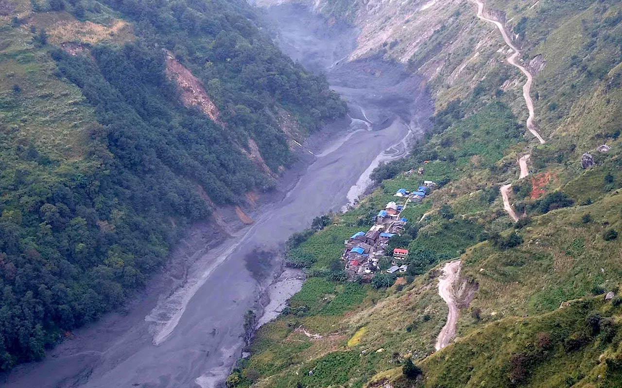
A sudden flood occurred in the Budhi Gandaki River corridor of north-central Nepal on Sunday, 11 October. Before the barrier collapsed, flooding was caused by a landslide blocking the river near Chumchure, the Associated Press reported.
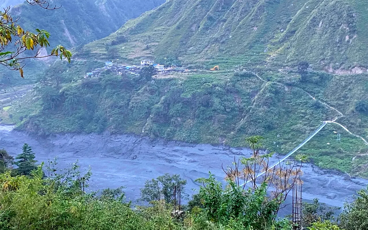
Initial reports described at least five people missing, 49 people rescued by Sunday afternoon, four bridges damaged and approximately three dozen houses swept away. A hydropower construction site and power and communication facilities were also damaged. The authorities evacuated villages that were at risk, such as the riverside community Arughat.
The numbers are provisional and are subject to change. Next priorities are the search for missing persons, assisting the affected residents and restoring access to key facilities.
The flood is especially threatening for trekking in the area, as the Budhi Gandaki passes through the lowest part of the Manaslu trekking route. But news of the overall river tragedy does not imply the condition of all bridges and walking trails that are used by trekkers.
How Has the Flood Affected the Manaslu Circuit Trek?
The Manaslu Circuit passes through remote villages in the Budhi Gandaki Valley, heading towards the higher villages in the Himalayas. The typical route starts with a road journey to Machha Khola from Kathmandu and then a trek through Jagat, Deng, Namrung, Lho, Samagaun and Samdo. Then the trekkers pass over Larkya La Pass and head down towards Bimthang and Dharapani.
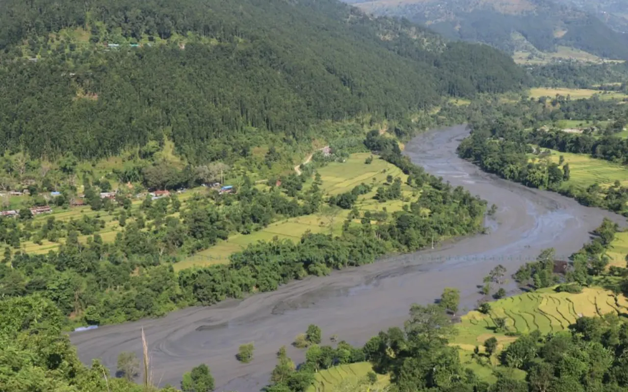
The lower valley is the main area of concern following the October flood. Trekking updates first indicate damage to bridges and walking paths on walking trails around Machha Khola, Jagat, Sirdibas and other settlements. The exact state of each crossing and whether this route is continuous should be visited on site.
This damage can affect access to villages further upstream from Budhi Gandaki where the floodwaters did not reach in the Manaslu Circuit Trek. Trekkers should not automatically presume that a route is passable because part of the trail can be seen or because a road is open a few kilometres away.
The route is also subject to local accommodation, food provision, transport and emergency access requirements. If the damage to these services makes a trek unfeasible, even in the immediate flood zone, it can have an impact.
Which Sections Are Affected and What Is Known About the Upper Route?
Machha Khola to Jagat
The lower trekking sector of Machha Khola and Jagat is of concern as it has river crossings and narrow trails adjacent to steep slopes. The local authorities report damage to a suspension bridge between Machha Khola and Kerauja and a crossing between Nyakchet and Sirdibas. A steel bridge was also reported as swept away near Soti.
These crossings serve local communities and travellers. Their loss can impede travel between settlements, even if portions of the walking track are not damaged. Other hazards that may not be apparent at the time may arise from trail erosion, unstable riverbanks and debris.
Jagat, Sirdibas and Philim
The surrounding communities of Jagat and its environs have also been impacted. Damage to houses along the river and damage to local infrastructure has been reported, as have some bridges used for connecting villages.
Before trekking, the condition of the entire route through this area should be looked at. The damaged crossing may need to be worked around by a long detour, but a makeshift crossing is not necessarily safe or practical for trekkers.
Deng, Namrung, Samagaun and Larkya La
There is not enough information at present to pinpoint the total amount of direct flooding damage at Deng, Namrung, Samagaun, Samdo or Larkya La Pass. Local information indicates that some damage was more direct on the upper route than the lower valley route.
Less direct damage does not necessarily mean that the upper route is safe and accessible, though. On the lower corridor, which remains blocked, the lower corridor is the first corridor through which the trekkers follow the standard itinerary.
Under normal conditions, Larkya La Pass (5,106 m/16,752 ft) is a high mountain pass that needs careful planning. The biggest question on everyone’s mind right now is how safe it will be for trekkers to make it to the top route and if the proper places for staying the night, eating meals and having emergency help are available.
What Caused the Flood?
A landslide was reported to have closed a river in the Chumnubri area before the flood waters rushed down the river. Details of the events and site of the blockage varied in preliminary reports and the trigger and mechanism should not be accepted as fully established.
A landslide can temporarily block a river by depositing large quantities of soil, rocks and debris across its channel. Water builds up behind the blockage. When it fails, the water stored in the barrier can rush downstream, entraining sediment and debris and eroding bridges and river banks and causing damage to settlements.
Examples of this type of flooding can cause damage to areas far from the starting landslide. It can also cause hazards to remain behind when water levels recede, such as weak slopes, unstable ground and damaged crossings.
For trekkers, the critical factor is that a river that looks calm after a flood does not mean the path on the other side is safe. Damage assessments are required before re-entry by people into damaged areas.
Are Trekkers Stranded in the Manaslu Region?
Yes. A Reuters report published on 12 October said that more than 100 foreign trekkers had been stranded in the flood-affected area of Gorkha District. Rescue efforts were still underway, with authorities assisting visitors and residents to move to safety. Those who were impacted were either waiting for rescue or trekking through safe parts of the route, supported by local businesses within the Manaslu Conservation Area Project, the organization said.
The situation could vary greatly depending on the location of a trekking group at the time of the flood. Individuals in impacted lower settlements could be exposed to additional hazards compared to those already upstream and those who have crossed Larkya La and moved down towards Dharapani settlements.
In the region, trekkers should maintain contact with their licensed guides and remain under the instructions of local authorities and should not try to cross damaged crossings without the assistance of guides. They should not expect a familiar trail to be open because they walked up it prior to the flood.
Rescue and local authorities need to determine movements that are safe. Avoid travelling through damaged areas to try to get to a road or to the starting point.
Is the Manaslu Circuit Trek Safe After the Flood?
For the time being, the best option is to delay new travel until the affected route is inspected and it is safe to travel. This is a recommendation and not an official closure of all parts of the circuit due to damage, with no access being reported.
The Manaslu trekking safety update is especially relevant for those who are considering traveling in October and November. Weather is not a sufficient basis for determining bridge, trail and road safety.
Trails that have been rendered unsafe by flooding may become caving underfoot and rocks and muddy slopes can still be hazardous after the floodwaters have subsided. Lack of bridges can also result in a lack of safe river crossings for trekkers. When rescue access and communication services are compromised, these problems become more dire.
Route information is available from the District Administration Office, Gorkha and the Manaslu Conservation Area Project. It’s also imperative that trekking companies receive firsthand information from guides and communities on the course they are mapping out.
As of 12 October 2026, no confirmed date for the full reopening of the affected corridor is available in the information reviewed for this article.
What Should Travellers With Upcoming Bookings Do?
Those who have booked a trek to Manaslu should reach the trek agency before heading out for the trek. Request a complete plan for the route, such as roads, bridges and accommodations.
The conditions of the Manaslu Circuit Trek should be evaluated for the whole trek and not just for the first walking day or the upper mountain section. Although some villages are still accessible, this does not ensure that a full tour of the village can be safely made.
Consideration of postponing, rescheduling and refund conditions should also be discussed before a change of plans. Inquire if travel insurance includes trip interruption, emergency evacuation and trekking in areas where the government has issued warnings. Coverage will vary based on the individual policy; verification with the insurance provider is a must.
Avoid taking unofficial shortcuts, crossing over damaged bridges and unofficial river crossings without authorization and thorough safety evaluation. Follow local authorities’ orders to stay in your safe place.
Visitors already in the area should remain with their guide and obey local authorities’ instructions. If communication is a problem, they should seek to get to a safe place under local guidance, rather than trying to complete the itinerary.
When Will the Manaslu Circuit Reopen?
As of 12 October 2026, there is no official date for the reopening of the affected lower Manaslu corridor. Timing will be dependent on the level of damage, river conditions, inspections and re-establishment of safe pedestrian routes.
Authorities and relevant teams will have to evaluate damaged bridges, inspect eroded trails and unstable slopes and set up safe routes between villages before trekking can be resumed. Road links, housing, communications and emergency assistance may need to be addressed as well.
Reopening could be gradual instead of all at once in the circuit. Breaking open a road or the repair of a bridge would not guarantee that all trekking sections would be safe.
For the Manaslu Circuit Trek after the Budhi Gandaki flood, people need to refer to a dated update to reconfirm the section of the trek. The general comment on better weather or no change in the upper villages is not enough to justify a leave.
What Does the Flood Mean for Local Communities?
The effects are far more than just on tourism. Roads, bridges and footpaths are critical for access by residents of Budhi Gandaki Valley to healthcare, schools, food supplies and other essential services. Flood damage to homes and local infrastructure can affect daily life long after the initial flood event.
Income is also generated during the autumn trekking season from guides, porters, transport operators, teahouses and small shops. These workers and businesses can lose valuable seasonal income when there are no routes available.
But the restoration of tourism should come after ensuring safe access and basic services. Time and support are needed to enable local people and rescue and repair teams to react to the disaster.
Restrictions should be respected, affected areas avoided and bookings changed responsibly with the trekking agency by the travellers. Additional requirements for safe decision-making should not be imposed on communities already coping with the effects of the flood.
Frequently Asked Questions
Can I start the Manaslu Circuit Trek in October 2026?
New travel plans should be delayed until the affected route is evaluated and it is safe to travel on. This could be subject to change and as of 12 October, it has yet to be confirmed.
Is Larkya La Pass damaged?
The reports reviewed do not indicate any direct flood damage to Larkya La Pass (5,106 m /16,752 ft). This does not mean that the pass is open or the trek is available.
Is the Tsum Valley Trek affected?
Yes. The Tsum Valley approach takes parts of the lower Budhi Gandaki route and there are reports that access has been blocked. It is recommended that travellers delay entry on this trek until they have confirmation that it is safe to do so.
Can I choose another trekking destination in Nepal?
Maybe, but other destinations must be checked for the conditions of the trails, accessibility of transport, weather and any current restrictions. Please don’t assume that another region is safe because it is not part of the affected river corridor.
Where can I get reliable updates?
Please get in touch with the trekking company and also update with the following offices: District Administration Office, Gorkha, Manaslu Conservation Area Project and relevant disaster management institutions of Nepal. Find out information that is up-to-date and relevant to your intended route.
Final Thoughts
The Budhi Gandaki flood on 11 October 2026 has caused serious disruption in the Manaslu region, with damaged bridges, affected settlements and interruptions to trekking access. Local recovery and rescue operations are still key priorities.
The Manaslu Circuit Trek after the Budhi Gandaki flood can be re-opened after the infrastructure and the affected parts of the trekking route have been inspected and made safe. For now, though, the absence of any confirmation of access should not be interpreted as presuming that the path is clear for new departures.
When traveling, the simple steps are: check with trusted local sources, be flexible with reservations and listen to official local safety guidelines. The reopening of the circuit should be based on verified conditions, not on assuming worst flood conditions in the upper mountains along the entire circuit.


